Deepwater Sedimentary Systems of the Taranaki Basin: Outer Shelf to Basin Plain Petroleum Reservoir Analogues (FTP10)
Description
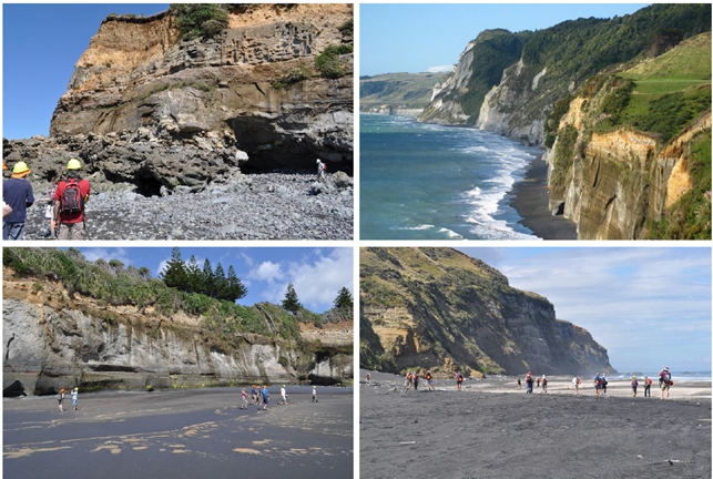
The Taranaki Basin is one of the few places in the world with such an exceptional and complete transect of upper slope to basin floor clastic deposits in outcrop. A superb field area to learn about deepwater reservoirs, seals and traps.
The Miocene deepwater deposits of the Taranaki Basin are spectacularly exposed about 40 km northeast of New Plymouth, New Zealand. This is an opportunity to learn about the stratigraphic evolution of shelf, slope, base-of-slope, and basin-floor volcaniclastic and siliciclastic assemblages that can be traced offshore to producing oil and gas fields. The processes of sedimentation and stratigraphic architecture of predominantly fine- to very fine-grained channel-fill, levee, splay (overbank, avulsion, frontal, and crevasse types), and seismic-scale mass-transport deposits will be featured from slope to basin floor, and will include visits to the Mohakatino (basin floor), upper and lower Mount Messenger (slope to base of slope), and Urenui (shelf to slope) formations.
Key risks in oil and gas drilling including reservoir presence, reservoir deliverability, trap, and seal presence will be main discussions at each stop in the itinerary, as well as recent publications on the basin featured in the research journals Marine and Petroleum Geology and AAPG Bulletin as well as Deepwater Sedimentary Systems: Science, Discovery and Applications. Located in a hybrid basin setting, these outcrops have been applied as analogues for decades to help understand geologic risk and associated uncertainty, 3D reservoir architecture, reservoir connectivity, up- to down-system and lateral turbidite distribution, and source-to-sink linkages in both active and passive margin plays.
Course Level: Skill
Duration: 5 days
Instructor: Jon Rotzien
Designed for you, if you are...
- A geologist or geophysicist
- A reservoir engineer
- A manager
Physical Demands
- Difficulty of the hikes is from easy to moderate, taking place along fine-grained sandy to rocky beaches. Participants will walk on water and sand, which are not robust surfaces, for long days on the outcrop.
- Sturdy boots and hard hats are necessary.
How we build your confidence
The benefits from attending
This course will give you an understanding of the broad scope of deepwater clastic depositional systems.By the end of the course, you will be able to:
- Describe transport and depositional processes of deepwater rocks including turbidites, debrites, and transitional to hybrid flow type deposits
- Understand the stratigraphy related to passive and active margin turbidite systems
- Characterize and interpret the different types of marine depositional environments (outer shelf, deltaic to deepwater canyon, channel, levee, splay, overbank) and their implications to reservoir architecture and reservoir quality
- Describe and apply the Miocene regional chronostratigraphy of the Wai-iti Group
- Understand both plate tectonics and lithospheric architecture and their roles on the development of retroarc foreland basin and hybrid basin depositional systems
- Recognize the relationships of sediment transport and deposition in deepwater depositional environments, and competing models for Taranaki Basin sedimentation
- Characterize deepwater reservoirs and build relationships with depositional environments using outcrop (and behind-outcrop core), core, and other industry data
- Use lithofacies and stratigraphic architecture to understand variations in deepwater reservoir properties pertaining to reservoir presence, reservoir quality, and seal presence
- Apply predictive attributes to deepwater reservoirs in the context of reservoir development, with special attention to stratigraphic trapping mechanisms
- Conceptualize and apply source-to-sink transport and sequence stratigraphy to marine sediment delivery
- Apply skills in seismic interpretation, reservoir characterization, core analysis, geophysical log interpretation, sequence stratigraphy, play fairway mapping, risk and uncertainty analysis, gross depositional environment mapping, and oil and gas exploration methods
Topics
- Pre Field Trip Meeting: welcome and introductory lecture on the Taranaki Basin
- Day 1: Base-of-slope assemblages of the Upper Mount Messenger along Pukearuhe Beach
- Day 2: Channel-lobe transition zone and channel mouth depositional environments represented by the Lower Mount Messenger Formation near Tongaporutu
- Day 3: Channel-fill and overbank assemblages at Waikiki Beach; shelf to slope channel-fill and overbank assemblages of the Urenui Formation near Urenui
- Day 4: Mass-transport complexes of the Lower Mount Messenger Formation at Rapanui Stream and Jamroll
- Day 5: Basin-floor fan environments near Awakino and Mohakatino
© All rights reserved
HOT Engineering GmbH Tel: +43 3842 43 0 53-0 Fax +43 3842 43 0 53-1 hot@hoteng.com